Projects that use our instruments determine the research they conduct.
Most projects focus on resource deposits and mining environments, environmental seismology (groundwater, ice, and glaciers), geothermal, and teaching.
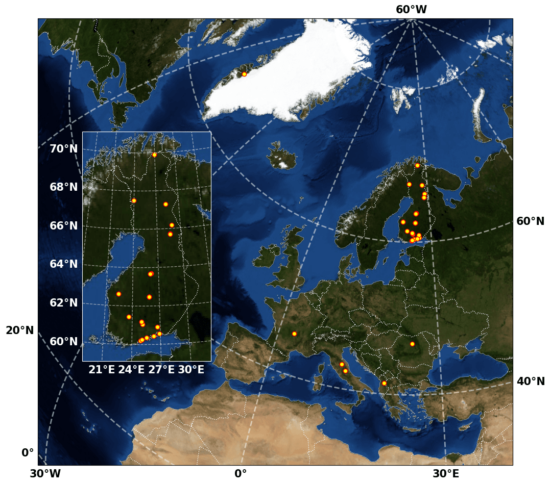
On this page, you can find a non-exhaustive list of the projects the pool has served, along with a map of their approximate locations.
- KySe – Kymenlaakso Seismic Experiment
The Kymenlaakso rapakivi granite region exhibits a higher level of seismicity when compared to other regions in Finland. The KySe 2026 project aims to collect seismic data in the coastal and archipelago regions around the municipalities of Kotka, Hamina and Virolahti in southeastern Finland. - CINTEM – Circularity-Integrated Mining
Passive seismics for structural health monitoring with a focus on tailings facilities. CINTEM is circular integrated mining across the value chain, which includes process and data flows as well as technologies enabling the sustainability of the mining industry.
CINTEM is a Co-Innovation project funded by Business Finland. - HUG – Hydrogen Underground
The Hydrogen Underground project aims to investigate the possibilities for constructing and utilizing underground hydrogen storage in Finland. As part of the project, a number of field investigations were planned at an exemplary sitting site, including a small, dense 3D seismic survey, with use of FINNSIP instruments, aimed at a structural characterization of the site. - DYNALake – Dynamics of a frozen lake environment
(Documentary available on the University of Helsinki YouTube channel)
The structural properties of subarctic lake ice are influenced by meteorological and environmental factors including ebullition of greenhouse gases from the lake sediment. We install 300 seismic sensors on and around Lake Pääjärvi, 100 km north of Helsinki, to record the elastic waves propagating in the ice sheet. Using seismic methods we study the dynamic ice response to environmental drivers, yielding high-resolution icequake distributions indicative of ice deformation patterns. Supported by water sampling and sounding we aim to resolve the variation of degassing methane that interacts with the ice to explore the applicability of seismic lake ice tomography for improved estimates of greenhouse gas emissions. The DYNALake project contributes to safe commercial and recreational participation in seasonal cryo environments, and opens new ways for climate monitoring.
DYNALake project has been funded by the Research Council of Finland (grant decision numbers 362968 and 359182). - UNDERCOVER – Unified Novel Deep ExploRation for Critical Ore discoVERy
UNDERCOVER’s research is unlocking the discovery of critical raw materials (CRMs) buried deep beneath the Earth’s surface. With cutting-edge technologies and a commitment to sustainability, we’re pushing exploration beyond the usual uppermost few hundred meters.
The UNDERCOVER project has received funding from the European Union’s Horizon Europe Research and Innovation Programme under Grant Agreement No.101177528. - MACIV – Multi-scale seismic imaging of Massif Central focussing on recent intraplate volcanism
The MACIV project (Multiscale seismic imaging of the Massif Central focusing on recent intraplate volcanism) aims at better understanding the sources of deep-seated volcanism in the French Massif Central by implementing the most innovative seismic tomography methods, based on a series of temporary, multi-scale, passive seismological experiments.
MACIF is funded by ANR (Agence Nationale de la recherche, projet ANR-22-CE49-0019), for the time period 2023-2028. - Geoenergialoikka
Geothermal site studies and regional structural studies to support utilisation of geothermal energy in Kymenlaakso.
Co-funded by the European Union. - Mine.io
Digitalisation of passive seismic imaging applied to tailings facilities. MINE.IO project focus on industrialisation, informatisation of the mining sector. By digitalising geophysical workflows for data acquisition and data processing the project aims to provide a tangible solution enabling a mining digital ecosystem in the context of industry 4.0. - REASSESS – Probing and predicting the dynamical response of the Greenland-Ice-Sheet to surface melt water
Inaction on climate change has resulted in rising sea levels and unforeseen or incompletely understood environmental responses. Over the past three decades, the Greenland ice sheet’s contribution to sea level rise has significantly increased, confounding scientists who struggle to discern the underlying mechanisms driving this escalation. In this context, the ERC-funded REASSESS project has successfully revisited a previous theory from a fresh perspective, potentially paving the way for significant new discoveries. The project aims to enhance comprehension and advance research on managing surface meltwater’s impact on ice loss attributable to glacier morphology. It will employ innovative methodologies and modelling technologies for this purpose. - SEEMS DEEP – Seismic and Electromagnetic methods for deep exploration
SEEMS DEEP project is developing a novel workflow integrating seismic and various electromagnetic methods to serve deep mineral exploration. - Water-Seismic – Full-waveform inversion techniques for estimation of groundwater volume
This project focuses on developing advanced methods for monitoring groundwater resources in aquifers using seismic surface measurements. Machine learning techniques are applied to estimate key parameters, such as water volume, directly from seismic data. - HYBGEO-GEKE
The Pirkkala survey, carried out within the HYBGEO and Geke projects, focused on developing medium-deep geothermal energy in urban areas through noninvasive seismic methods and fracture zone assessment. Seismic profiles were collected using FINNSIP instruments and a GTK-owned landstreamer, complemented by a small-scale passive array and a zero-offset VSP with Distributed Acoustic Sensing to characterize subsurface structures and fracturing. - SCARCE: Scandinavian Arctic seismic profile
Studying crustal structures and local seismicity in the border area of Finland and Norway, the 300km long profile continuing to the Barents sea via Varanger Peninsula. - Koillismaa – Regional seismic investigations in Koillismaa and Sodankylä
An 8-km long crooked seismic profile was acquired in the vicinity of the GTK’s Koillismaa deep drillhole. A mix of Vibroseis and explosive sources was used together with 750 GSB receivers. New data show the complex shape of the Koillismaa intrusion, as well as the dikes cross-cutting the Archean basement. This profile was a pilot before larger-scale 2D and 3D seismic acquisition in the SEEMS DEEP project. - Kurikka DAS – Groundwater investigations at Kurikka using seismic with geophones and DAS
In the quest to further develop the potential of seismic methods to study complex groundwater system in Kurikka, GTK acquired two pilot 2D surveys in the area in 2021 and 2022. In both cases, 500 GSB nodes were used. We tested a small electrically driven seismic vibrator (E-vib) operating in both P- and S-wave mode. Reflection seismic sections were complemented with the P- and S-wave velocities from first-arrival tomography, facilitating interpretation of the fresh vs weathered bedrock. In the 2022 survey, additional measurements were performed using Distributed Acoustic Sensing. - AdriaArray
AdriaArray is a multi-national effort to cover the Adriatic Plate and its active margins in the central Mediterranean by a dense regional array of seismic stations to understand the causes of active tectonics and volcanic fields in the region.